River Habitat Restoration Survey
Project Overview
The Lower Muskegon River is a designated Great Lakes Area of Concern (AOC). Years of poor environmental stewardship and a lack of a proper land survey left its wetlands unable to filter surface water runoff or provide flood control as it once did. Environmental degradation on the 60-acre site included burnt fields from sulfate emissions, soil and water contamination from oil seepage and other pollution.
Fleis & VandenBrink was tasked with improving and restoring the wetlands and habitat, which in turn aids in the removal of the the AOC designation. Obtaining the land survey data for accurate mapping of the site was difficult with conventional techniques due to the site’s diversity of conditions. The AOC included former celery fields, a river, wetlands, bog/marsh and a man-made dike/levee. A high-quality map of the terrain to develop the restoration plans was needed. Some areas of the site were not safe for the Fleis & VandenBrink staff to access by walking and other areas of the site were inaccessible by a full-size boat or canoe.
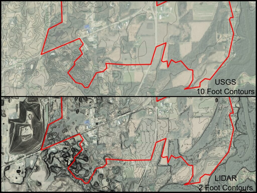
The Fleis & VandenBrink land survey team found a way to get onto the site and obtain the necessary detailed survey data for the entire site. This included both a site topographic survey to identify and map the contours of the ground and all existing site features, and a bathymetric survey for the river’s depths and contours. Fleis & VandenBrink’s land survey team developed a plan to use multiple surveying techniques to efficiently map each of the types of terrain found on the site and combine them into a single comprehensive map. The Fleis & VandenBrink land survey team used a Total Robotic Station (RTS) and Global Positioning System (GPS) and integrated them with a remote controlled boat and aerial drone to perform the topographic, bathymetric and aerial photogrammetric surveys.
This land survey process captured roughly 10-times more data points than regular methods, yielding a very accurate map of the 60-acre site for habitat and wetlands restoration designers to use in their design. The extra data points provided the designers accurate and precise details needed to evaluate the stormwater patterns across the site, help re-designate an AOC area and increase the quality of life – for plants, animals and humans.
The project was honored with a 2017 Honorable Conceptor Award from the American Council of Engineering Companies – MI.