Hear from Our Past Clients

What We Do
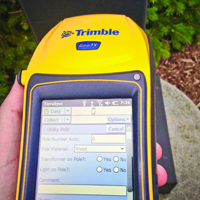
A Geographic Information System (GIS) helps tie together location, asset details, and documentation so staff can answer real operational questions fast. On the F&V side, this work commonly starts after construction, when inspectors collect GPS points on new infrastructure and upload that data into your GIS so records stay current.
Depending on what you need, GIS services may include:
- Utility and asset inventories (water, sanitary, storm, and other public assets).
- Mobile field data collection workflows.
- Record digitization and GIS-linked document libraries.
- Mapping and spatial analysis for planning and operations.
- Ongoing maintenance for parcels, streets, zoning, and GIS layers.
Use GIS to visualize asset condition, find patterns, and sort infrastructure by attributes (like pipe size or material) to support repair planning and reporting.
Where We Work
Tell Us About Your Project
Need help getting post-construction data, records, and mapping into a GIS your team can rely on? Reach out to Fleis & VandenBrink to talk through your workflow and what you want your GIS to do next.
Who We Serve
Municipalities
We support GIS programs used by public works, utilities, engineering, and planning staff to manage assets, records, and post-construction updates.
Community Services
We provide mapping and data management support for public-facing services that rely on accurate location data for planning, maintenance, and coordination.
Commercial Businesses
We develop and maintain GIS layers that support facility management, site planning, asset tracking, and internal mapping needs.
Educational Institutions
We assist schools and universities with campus mapping, asset inventories, utility records, and GIS systems that support long-term planning.
Homeowners Associations
We maintain GIS records for shared infrastructure, parcels, utilities, and community assets to support maintenance planning and documentation.
Private Clients
We deliver GIS mapping, data organization, and spatial analysis for clients who need location-based records tied to real-world conditions.


Frequently Asked Questions
GIS services organize location-based data so a city or utility can map assets, attach records, and query what is in the ground, where it is, and what condition it is in.